
 |
Alfred Wegener (1880-1930)  Alfred Wegener (1880-1930)
.
Some truly revolutionary scientific theories may take years or decades to win general acceptance among scientists. This is certainly true of plate tectonics, one of the most important and far-ranging geological theories of all time; when first proposed, it was ridiculed, but steadily accumulating evidence finally prompted its acceptance, with immense consequences for geology, geophysics, oceanography, and paleontology. And the man who first proposed this theory was a brilliant interdisciplinary scientist, Alfred Wegener. Born on November 1, 1880, Alfred Lothar Wegener earned a Ph.D in astronomy from the University of Berlin in 1904. However, he had always been interested in geophysics, and also became fascinated with the developing fields of meteorology and climatology. During his life, Wegener made several key contributions to meteorology: he pioneered the use of balloons to track air circulation, and wrote a textbook that became standard throughout Germany. In 1906 Wegener joined an expedition to Greenland to study polar air circulation. Returning, he accepted a post as tutor at the University of Marburg, taking time to visit Greenland again in 1912-1913. (The above photograph of Wegener was taken during this expedition). In 1914 he was drafted into the German army, but was released from combat duty after being wounded, and served out the war in the Army weather forecasting service. After the war, Wegener returned to Marburg, but became frustrated with the obstacles to advancement placed in his way; in 1924 he accepted a specially created professorship in meteorology and geophysics at the University of Graz, in Austria. Wegener made what was to be his last expedition to Greenland in 1930. While returning from a rescue expedition that brought food to a party of his colleagues camped in the middle of the Greenland icecap, he died, a day or two after his fiftieth birthday. While at Marburg, in the autumn of 1911, Wegener was browsing in the university library when he came across a scientific paper that listed fossils of identical plants and animals found on opposite sides of the Atlantic. Intrigued by this information, Wegener began to look for, and find, more cases of similar organisms separated by great oceans. Orthodox science at the time explained such cases by postulating that land bridges, now sunken, had once connected far-flung continents. But Wegener noticed the close fit between the coastlines of Africa and South America. Might the similarities among organisms be due, not to land bridges, but to the continents having been joined together at one time? As he later wrote: "A conviction of the fundamental soundness of the idea took root in my mind." Such an insight, to be accepted, would require large amounts of supporting evidence. Wegener found that large-scale geological features on separated continents often matched very closely when the continents were brought together. For example, the Appalachian mountains of eastern North America matched with the Scottish Highlands, and the distinctive rock strata of the Karroo system of South Africa were identical to those of the Santa Catarina system in Brazil. Wegener also found that the fossils found in a certain place often indicated a climate utterly different from the climate of today: for example, fossils of tropical plants, such as ferns and cycads, are found today on the Arctic island of Spitsbergen. All of these facts supported Wegener's theory of "continental drift." In 1915 the first edition of The Origin of Continents and Oceans, a book outlining Wegener's theory, was published; expanded editions were published in 1920, 1922, and 1929. About 300 million years ago, claimed Wegener, the continents had formed a single mass, called Pangaea (from the Greek for "all the Earth"). Pangaea had rifted, or split, and its pieces had been moving away from each other ever since. Wegener was not the first to suggest that the continents had once been connected, but he was the first to present extensive evidence from several fields.
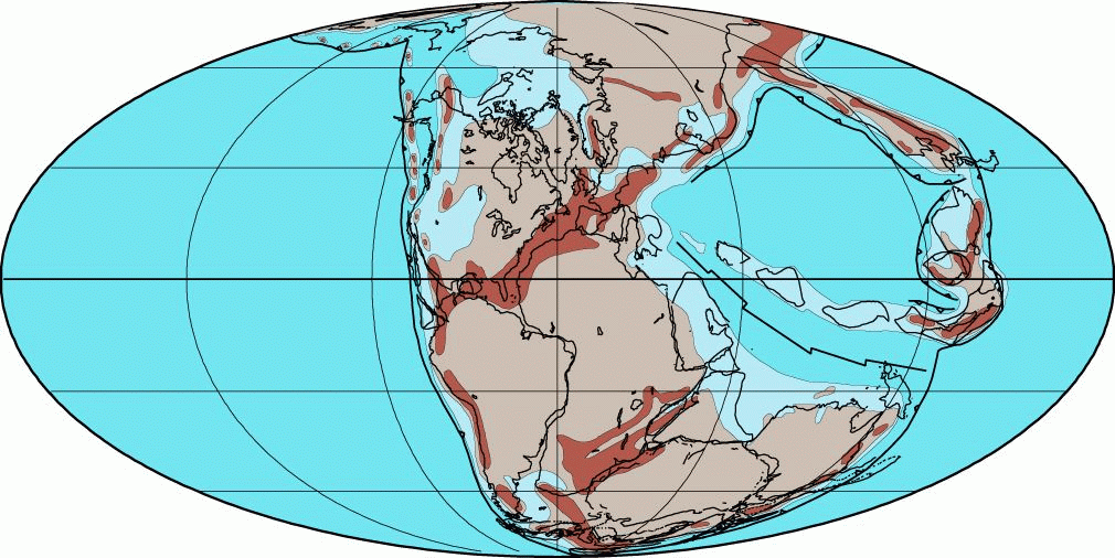
Modern reconstruction of Pangaea, ca. 255 million years ago -- click to view a much larger version of this map! Reaction to Wegener's theory was almost uniformly hostile, and often exceptionally harsh and scathing; Dr. Rollin T. Chamberlin of the University of Chicago said, "Wegener's hypothesis in general is of the footloose type, in that it takes considerable liberty with our globe, and is less bound by restrictions or tied down by awkward, ugly facts than most of its rival theories." Part of the problem was that Wegener had no convincing mechanism for how the continents might move. Wegener thought that the continents were moving through the earth's crust, like icebreakers plowing through ice sheets, and that centrifugal and tidal forces were responsible for moving the continents. Opponents of continental drift noted that plowing through oceanic crust would distort continents beyond recognition, and that centrifugal and tidal forces were far too weak to move continents -- one scientist calculated that a tidal force strong enough to move continents would cause the Earth to stop rotating in less than one year. Another problem was that flaws in Wegener's original data caused him to make some incorrect and outlandish predictions: he suggested that North America and Europe were moving apart at over 250 cm per year (about ten times the fastest rates seen today, and about a hundred times faster than the measured rate for North America and Europe). There were scientists who supported Wegener: the South African geologist Alexander Du Toit supported it as an explanation for the close similarity of strata and fossils between Africa and South America, and the Swiss geologist Émile Argand saw continental collisions as the best explanation for the folded and buckled strata that he observed in the Swiss Alps. Wegener's theory found more scattered support after his death, but the majority of geologists continued to believe in static continents and land bridges. What prompted the revival of continental drift? In large part it was increased exploration of the Earth's crust, notably the ocean floor, beginning in the 1950s and continuing on to the present day. By the late 1960s, plate tectonics was well supported and accepted by almost all geologists. We now know that Wegener's theory was wrong in one major point: continents do not plow through the ocean floor. Instead, both continents and ocean floor form solid plates, which "float" on the asthenosphere, the underlying rock that is under such tremendous heat and pressure that it behaves as an extremely viscous liquid. (Incidentally, this is why the older term "continental drift" is not quite accurate -- both continents and oceanic crust move.)
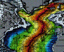 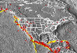
Since Wegener's day, scientists have mapped and explored the great system of oceanic ridges, the sites of frequent earthquakes, where molten rock rises from below the crust and hardens into new crust. We now know that the farther away you travel from a ridge, the older the crust is, and the older the sediments on top of the crust are. The clear implication is that the ridges are the sites where plates are moving apart (click on the picture at the left to see a map of the age of the ocean crust). Where plates collide, great mountain ranges may be pushed up, such as the Himalayas; or if one plate sinks below another, deep oceanic trenches and chains of volcanoes are formed. Earthquakes are by far most common along plate boundaries and rift zones: plotting the location of earthquakes allows seismologists to map plate boundaries and depths (click on the picture at the right to view a map of quake epicenters). Paleomagnetic data have allowed us to map past plate movements much more precisely than before. It is even possible to measure the speed of continental plates extremely accurately, using satellite technology. Nevertheless, Wegener's basic insights remain sound, and the lines of evidence that he used to support his theory are still actively being researched and expanded. Reproduced with kind permission of UCMP |
Follow me...
|


Cyberphysics - a web-based teaching aid - for students of physics, their teachers and parents....