
 |
Plate Tectonics Plate Tectonics, the Cause of Earthquakesby J. Louie (reproduced with kind permission)
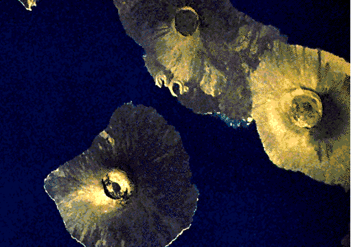
The plates consist of an outer layer of the Earth, the lithosphere, which is cool enough to behave as a more or less rigid shell. Occasionally the hot asthenosphere of the Earth finds a weak place in the lithosphere to rise buoyantly as a plume, or hotspot. The satellite image below shows the volcanic islands of the Galapagos hotspot.
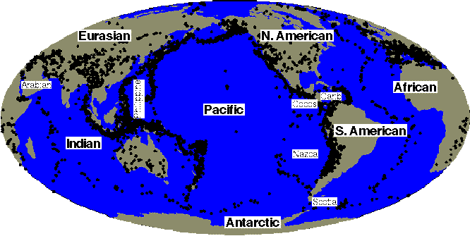
Only the lithosphere has the strength and the brittle behavior to fracture in an earthquake. The maps below shows earthquake occurances around the globe. They are not evenly distributed; the boundaries between the plates grind against each other, producing most earthquakes. So the lines of earthquakes help define the plates:
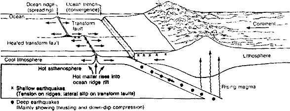
In cross section, the Earth releases its internal heat by convecting, or boiling much like a pot of pudding on the stove. Hot asthenospheric mantle rises to the surface and spreads laterally, transporting oceans and continents as on a slow conveyor belt. The speed of this motion is a few centimeters per year, about as fast as your fingernails grow. The new lithosphere, created at the ocean spreading centers, cools as it ages and eventually becomes dense enough to sink back into the mantle. The subducted crust releases water to form volcanic island chains above, and after a few hundred million years will be heated and recycled back to the spreading centers.
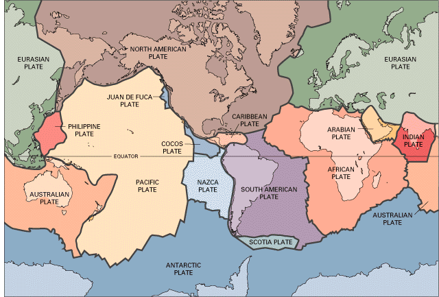
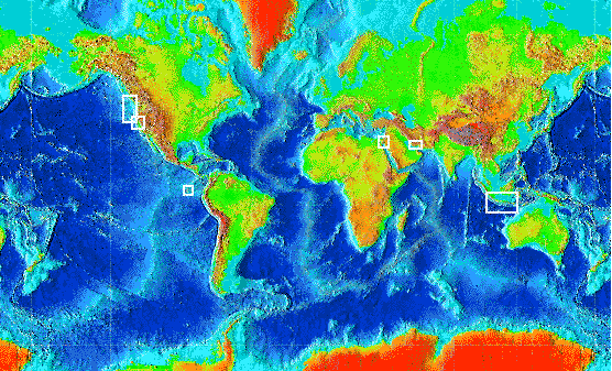
Earthquake occurrence in different plate tectonic settings:The map below of Earth's solid surface shows many of the features caused by plate tectonics. The oceanic ridges are the asthenospheric spreading centers, creating new oceanic crust. Subduction zones appear as deep oceanic trenches. Most of the continental mountain belts occur where plates are pressing against one another. The white squares locate examples given here of the different tectonic and earthquake environments.
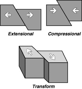
There are three main plate tectonic environments: extensional, transform, and compressional. Plate boundaries in different localities are subject to different inter-plate
stresses, producing these three types of earthquakes. Each type has its
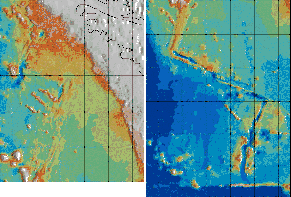
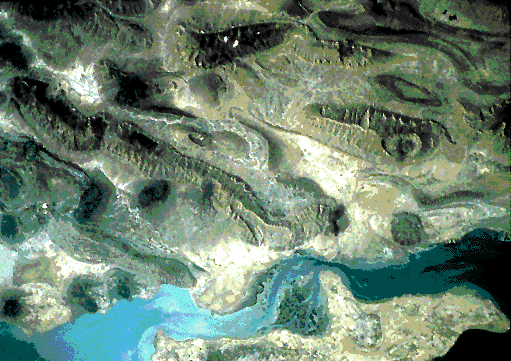
own special hazards. At spreading ridges, or similar extensional boundaries, earthquakes are shallow, aligned strictly along the axis of spreading, and show an extensional mechanism. Earthquakes in extensional environments tend to be smaller than magnitude 8. A close-up topographic picture of the Juan de Fuca spreading ridge, offshore of the Pacific Northwest, shows the turned-up edges of the spreading center. As crust moves away from the ridge it cools and sinks. The lateral offsets in the ridge are joined by transform faults.
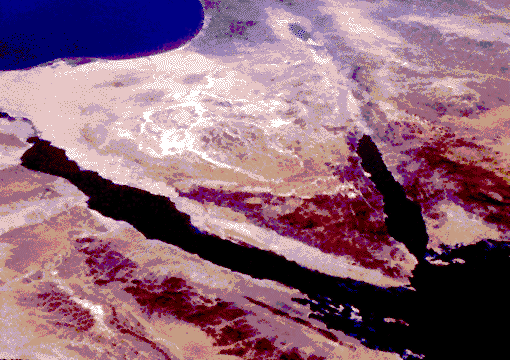
A satellite view of the Sinai shows two arms of the Red Sea spreading ridge, exposed on land.
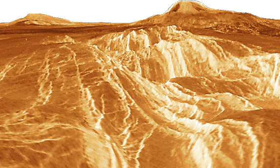
Extensional ridges exist elsewhere in the solar system,
although they never attain the globe-encircling extent the oceanic ridges
have on Earth. This synthetic perspective of a large volcano on Venus
is looking up the large rift on its flank.
At transforms, earthquakes are shallow, running as deep as 25 km; mechanisms indicate strike-slip motion. Transforms tend to have earthquakes smaller than magnitude 8.5. The San Andreas fault in California is a nearby example of a transform,
separating the Pacific from the North American plate. At transforms the
plates mostly slide past each other laterally, producing less sinking
or lifing of the ground than extensional or compressional environments.
The yellow dots below locate earthquakes along strands of this fault system
in the San Francisco Bay area.
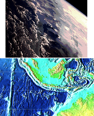
At compressional boundaries, earthquakes are found in several settings ranging from the very near surface to several hundred kilometers depth, since the coldness of the subducting plate permits brittle failure down to as much as 700 km. Compressional boundaries host Earth's largest quakes, with some events on subduction zones in Alaska and Chile having exceeded magnitude 9. This oblique orbital view looking east over Indonesia shows the clouded
tops of the chain of large volcanoes. The topography below shows the Indian
plate, streaked by hotspot traces and healed transforms, subducting at
the Javan Trench. Sometimes continental sections of plates collide; both
are too light for subduction to occur. The satellite image below shows
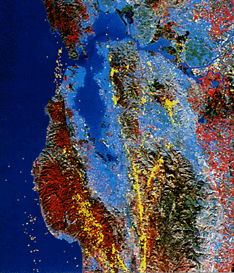
the bent and rippled rock layers of the Zagros Mountains in southern Iran,
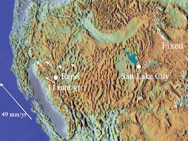
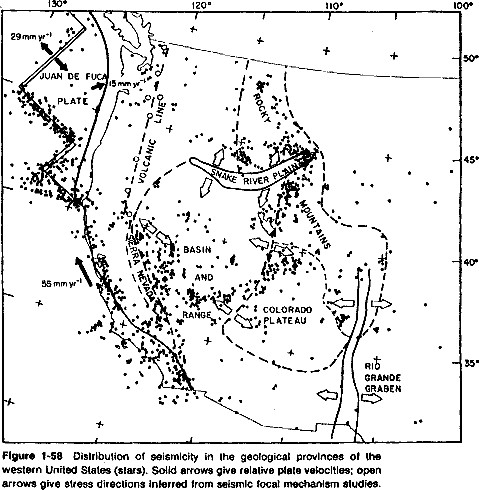
where the Arabian plate is impacting the Iranian plate. Nevada has a complex plate-tectonic environment,
dominated by a combination of extensional and transform motions. The Great
Basin shares some features with the great Tibetan and Anatolian plateaus.
All three have large areas of high elevation, and show varying amounts
of rifting and extension distributed across the regions. This is unlike
oceanic spreading centers, where rifting is concentrated narrowly along
the plate boundary. The numerous north-south mountain ranges that dominate
the landscape from Reno to Salt Lake City are the consequence of substantial
east-west extension, in which the total extension may be as much as a
factor of two over the past 20 million years.
As a result, Nevada hosts hundreds of active extensional
faults, and several significant transform fault zones as well. While not
as actively or rapidly deforming as the plate boundary in California,
Nevada has earthquakes over much larger areas. While some regions in California,
such as the western Sierra Nevada, appear to be isolated from earthquake
activity, earthquakes have occurred everywhere in Nevada.
|
Follow me...
|
 (from the USGS)
 (from NASA/JSC; topography from NOAA)


Cyberphysics - a web-based teaching aid - for students of physics, their teachers and parents....