Navigation Satellites

In the middle of the ocean or out of sight of landmarks, you can't find out your position accurately just by looking out the window. The idea of using satellites for navigation began with the launch of Sputnik 1 on October 4, 1957.
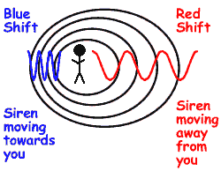 Scientists at the John Hopkins University's Applied Physics Laboratory monitored that satellite. They noticed that when the transmitted radio frequency was plotted on a graph, a pattern developed. This pattern was recognizable as the doppler effect. The doppler effect is an apparent change of radio frequency as something that emits a signal in the form of waves passes by. You will experience hearing a change in pitch when a siren goes past you at the roadside. This is the doppler effect. The lowering of the perceived frequency has the police car passes you is illustrated on the right.
Since the satellite was emitting a signal, scientists were able to show that the doppler curve described the orbit of the satellite.
 Today, most navigation systems use time and distance to determine location. they then use a computer system to analyse the data and pinpoint the position on a map graphic. This is far simpler than reading star positions and plotting points manually on a chart!
Given the velocity and the time required for a radio signal to be transmitted between two points, the distance between the two points can be worked out using the equation: velocity = distance travelled divided by time taken.
 The calculation must be done precisely, and the clocks in the satellite and in the ground-based receiver must be telling exactly the same time - they must be synchronized. If they are, the time it takes for a signal to travel can be measured and then multiplied by the exact speed of light to obtain the distance between the two positions.
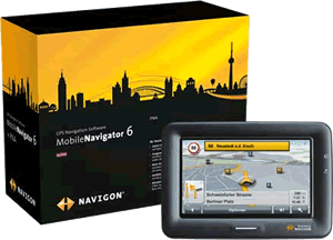
'Satnav' devices are now the 'must have' accessory for drivers. the technology has become much cheaper as it has been mass produced - economy of scale comes into play!